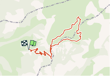
![](/images/other/stat-length.png)
![Tocht Stappen Le Vernet - 04 - Le Vernet - Circuit des 3 cabanes - Photo](https://media.geolcdn.com/t/1900/400/5f4f6b68-410e-4665-831f-4d845dee5ed7.jpg&format=pjpeg&maxdim=2)
04 - Le Vernet - Circuit des 3 cabanes
chris13370
Gebruiker
![Lengte](/images/other/stat-length.png)
![Max. hoogte](https://static1.geolcdn.com/siteimages/upload/files/1508320355ic_sort_altitude_max_24dp.png)
![Positief hoogteverschil](https://static1.geolcdn.com/siteimages/upload/files/1508320355ic_sort_den_pos_24dp.png)
![Km-Effort](/images/other/stat-length.png)
![Min. hoogte](https://static1.geolcdn.com/siteimages/upload/files/1508320355ic_sort_altitude_min_24dp.png)
![Negatief hoogteverschil](https://static1.geolcdn.com/siteimages/upload/files/1508320355ic_sort_den_neg_24dp.png)
![Boucle](https://static1.geolcdn.com/siteimages/upload/files/16400158638029165_repeat_loop_refresh_sync_direction_icon.png)
![Stappen](https://static1.geolcdn.com/sitytour/trail-icons/101.png)
5h30
Moeilijkheid : Medium
![Scan deze QR-code om de tocht te openen in de SityTrail-applicatie](https://capi.geolives.com/qq0zvz2zws4bq2lad0pu/sitytour/trails/2466083/qr.png?size=200)
Gratisgps-wandelapplicatie
Over ons
Tocht Stappen van 12,1 km beschikbaar op Provence-Alpes-Côte d'Azur, Alpes-de-Haute-Provence, Le Vernet. Deze tocht wordt voorgesteld door chris13370.
Beschrijving
Parking juste avant la barrière de la route forestière qui mène au col de Mariaud ( 2,1 km de montée, possibilité de couper les virages).
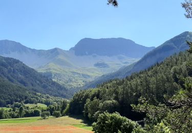
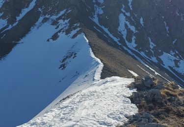
Très belle randonnée que nous avons faite début juillet ce qui explique qq difficultés à trouver le balisage du chemin enfoui sous le tapis de fleurs que les vaches n'avaient pas encore brouté.
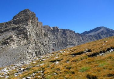
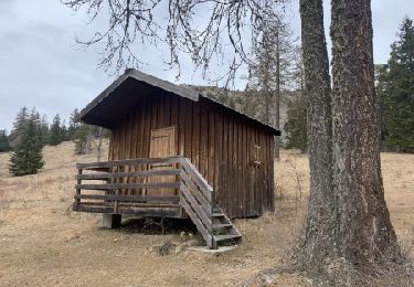
De plus le panneau de direction à la 1ère cabane (Val Pousane) n'était pas en place. qq errance en sorientant à vue car les 2 autres cabanes sont visibles.
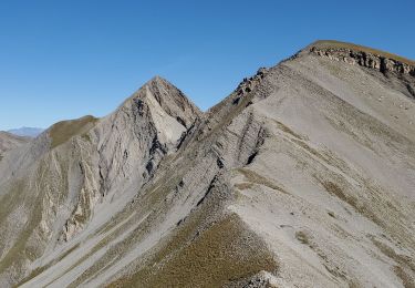
Très beaux alpages et panorama magnifique à 360 ° depuis le sommet du Pinet.
Plaatsbepaling
Opmerkingen
Wandeltochten in de omgeving
![Tocht Stappen Le Vernet - LE VERNET . COL DU MAL D HIVER . COL DU LABOURET . O L M - Photo](https://media.geolcdn.com/t/375/260/f7633ca9-7d5b-44f5-917e-1ea1f5fb10ea.jpg&format=jpg&maxdim=2)
![Stappen Stappen](https://static1.geolcdn.com/sitytour/trail-icons/101.png)
Stappen
![](/images/other/stat-length.png)
![](https://static1.geolcdn.com/siteimages/upload/files/16400158638029165_repeat_loop_refresh_sync_direction_icon.png)
![Tocht Stappen Le Vernet - VERNET . col de Mariaud. Les 3 cabanes o - Photo](https://media.geolcdn.com/t/375/260/ext.jpg?maxdim=2&url=https%3A%2F%2Fstatic1.geolcdn.com%2Fsiteimages%2Fupload%2Ffiles%2F1553511878bg_sport_marche.png)
![Stappen Stappen](https://static1.geolcdn.com/sitytour/trail-icons/101.png)
Stappen
![](/images/other/stat-length.png)
![](https://static1.geolcdn.com/siteimages/upload/files/16400158638029165_repeat_loop_refresh_sync_direction_icon.png)
![Tocht Stappen Seyne - SEYNES LES ALPES . Grand puy , montagne de la Blache , cabane du Mulet o l s - Photo](https://media.geolcdn.com/t/375/260/0a85776d-4fbe-44a9-8b16-bf4257f31cc2.jpg&format=jpg&maxdim=2)
![Stappen Stappen](https://static1.geolcdn.com/sitytour/trail-icons/101.png)
Stappen
![](/images/other/stat-length.png)
![](https://static1.geolcdn.com/siteimages/upload/files/16400158638029165_repeat_loop_refresh_sync_direction_icon.png)
![Tocht Stappen Seyne - tour de tourtourel - Photo](https://media.geolcdn.com/t/375/260/ext.jpg?maxdim=2&url=https%3A%2F%2Fstatic1.geolcdn.com%2Fsiteimages%2Fupload%2Ffiles%2F1553511878bg_sport_marche.png)
![Stappen Stappen](https://static1.geolcdn.com/sitytour/trail-icons/101.png)
Stappen
![](/images/other/stat-length.png)
![](https://static1.geolcdn.com/siteimages/upload/files/16400158638029165_repeat_loop_refresh_sync_direction_icon.png)
![Tocht Stappen Prads-Haute-Bléone - Estrop par Pic des Têtes - Photo](https://media.geolcdn.com/t/375/260/ext.jpg?maxdim=2&url=https%3A%2F%2Fservices.sitytrail.com%2FGeolivesWS%2FDownloadMedia.ashx%3FTrailID%3D452152%26Media%3D673d9b5f-8851-4b41-9daf-25b8a44f9005.jpg)
![Stappen Stappen](https://static1.geolcdn.com/sitytour/trail-icons/101.png)
Stappen
![](/images/other/stat-length.png)
![](https://static1.geolcdn.com/siteimages/upload/files/16400158638029165_repeat_loop_refresh_sync_direction_icon.png)
![Tocht Stappen Seyne - dos de chameau 1165m 12kms - Photo](https://media.geolcdn.com/t/375/260/20594f73-6d6a-4dc1-92d9-8c17fbfc97a8.jpg&format=jpg&maxdim=2)
![Stappen Stappen](https://static1.geolcdn.com/sitytour/trail-icons/101.png)
Stappen
![](/images/other/stat-length.png)
![](https://static1.geolcdn.com/siteimages/upload/files/16400158638029165_repeat_loop_refresh_sync_direction_icon.png)
![Tocht Stappen Le Vernet - grisonniere montagne ubac belliers960m 15kms - Photo](https://media.geolcdn.com/t/375/260/be9eca9e-a641-4422-8867-7fa326600209.jpg&format=jpg&maxdim=2)
![Stappen Stappen](https://static1.geolcdn.com/sitytour/trail-icons/101.png)
Stappen
![](/images/other/stat-length.png)
![](https://static1.geolcdn.com/siteimages/upload/files/16400158638029165_repeat_loop_refresh_sync_direction_icon.png)
![Tocht Stappen Seyne - Seyne première bosse dos de chameau 9km 950m - Photo](https://media.geolcdn.com/t/375/260/5e0390cb-740a-4758-8977-417cce7cc0a2.jpg&format=jpg&maxdim=2)
![Stappen Stappen](https://static1.geolcdn.com/sitytour/trail-icons/101.png)
Stappen
![](/images/other/stat-length.png)
![](https://static1.geolcdn.com/siteimages/upload/files/16400158638029165_repeat_loop_refresh_sync_direction_icon.png)
![Tocht Te voet Le Vernet - Boucle route des Béliers-Le col de Mariaud-Barre des Béliers-Col de la Grisonnière-Cabane du berger - Photo](https://media.geolcdn.com/t/375/260/2db42dd5-9a9c-4bfd-a26c-d699435386fb.jpg&format=jpg&maxdim=2)
![Te voet Te voet](https://static1.geolcdn.com/sitytour/trail-icons/100.png)
Te voet
![](/images/other/stat-length.png)
![](https://static1.geolcdn.com/siteimages/upload/files/16400158638029165_repeat_loop_refresh_sync_direction_icon.png)